Labels

Thursday, 9 February 2023

Doonside

 Nurragingy Reserve

Yesterday Nick drove us to the Nurragingy Reserve in Knox Road, Doonside.  This is an amazing 63 hectare bushland reserve which has several main attractions.  Prior to the 1970's, the land was part of the Cumberland Timber Forest, but it was then purchased by the New South Wales State Government with the intention of turning it into a green belt for rapidly expanding Western Sydney.  A portion of this land was to be used as a recreational area. 

The name Nurragingy commemorates one of the two men of the Dharug tribe who recived the first land grant to Aboriginal people from Governor Lachlan Macquarie in 1819.  The other title holder was Colebee, whose name has been given to the Centre within the Reserve.   

We walked to the Chang Lai Yuan Chinese garden which is styled with elements from both the Ming Dynasty and Qing Dynasty and includes a Gateway, Seven Arch Stone Bridge, a Light Mountain Pavilion and a Waterfall Gazebo. 

A Pai Lou (Gateway) is the first and most prominent building feature in the garden.  This Pai Lou has classical Chinese design character with an even number of columns creating a main centre passage and two side passages.  The roof features glazed tiles on upturned corner eaves, a design  popular in the 14th century Ming Dynasty.

A stone bridge and water is an essential feature in traditional garden designs.  The bridge forms a link between the different sections of the landscape.  The parapets are constructed in stone with carvings done by Master Stonemasons from China based on the style of the Imperial Court.


A Pavilion in the Chang Lai Yuan Chinese Garden.  The timber elements of all buildings were constructed in China and shipped here in containers.  They were reassembled by Chinese carpenters and hand painted by Chinese artisans.
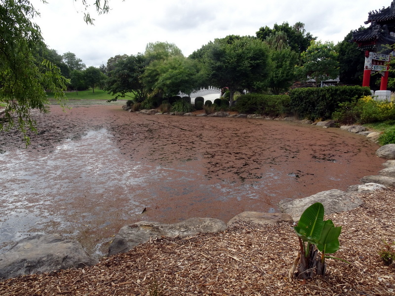
The native fern Azolla growing on the surface of the Lake.  It floats in a pink mass on top of the water.  It changes from green to pink in the sun.


A little grove of Boab trees growing in the Africa section.  These trees also grow in the Northern regions of Western Australia and in the Northern Territory of Australia.  They are easily recognised by the swollen base of their trunks giving the tree a bottle like appearance.

We also walked through areas devoted to Mediterranean plants, New Zealand plants and also plants from the Americas.

We enjoyed our visit to Nurragingy Reserve and look forward to another visit soon when we shall seek out the Aboriginal Heritage Section of the garden and other features we were not able to fit in on our visit yesterday.

Acknowledgments
1.  Wikipedia
2.  landscapesolutions.com.au
3.  various signage displayed in the garden.  

Tuesday, 24 January 2023

Brooklyn

Postman's Run on the Hawkesbury River

Last Sunday we joined the Travel Club for a Sunday outing on the Riverboat Postman on the Hawkesbury River.  It was a wet day, not the best day for being on the river, but needless to say it was still very enjoyable.  The Riverboat Postman is a daily mail service delivering mail and provisions to the isolated water-access-only residents of the lower Hawkesury River.   There has been a mail delivery service to these remote residents for over one hundred years, but on Sundays they take a break from delivering the mail and do a sight-seeing cruise in the opposite direction.  They cruise past the several islands in the river, past the National Parks and go as far as the entrance into Broken Bay.

We arrived at Brooklyn Wharf by tourist coach in the pouring rain.  We left the bus and raising our  umbrellas, we queued up to walk through the cutest little boat shed and out on to the gangplank to board our big stable catamaran for the luncheon cruise on the Hawkesbury River.  It was warm and dry inside the boat and we sat, in groups, at long tables with a good view of the river through the wrap-around windows.  We had morning tea with home-made Anzac biscuits and cups of tea and coffee as we began the cruise past Dangar Island.  Lunch was an Aussie Ploughman's-style plate with cold meats and a salad topped with a Turkish bread roll, pickles, chutney, butter and dressing.     There was a bar on board and wine and beer and soft drinks were available.

We passed under the Brooklyn rail and road bridges and saw the rusting wreck of Australia's first warship, the HMAS Parramatta lying in the mud flats near Milson Island.  We saw sea eagles soaring high in the sky above the sandstone ridges.   We cruised in close along the waterline, so we could see several Aboriginal rock carvings.  Ken also saw some jellyfish in the water and tried to photograph them. 

I was amazed at the size of the River.  It is known as "Derrubbin" by the local Dharug, Wannungine, Darkinung, Eora and Kuring-gai indigenous people.  This means "wide, deep water".  They used the river as a source of food, such as fish, eels, water birds and mussels.  Yams, also a staple food, grew along the banks of the river.  They travelled on the river in their bark canoes.

In the early days of European settlement, the River was an agricultural highway used to transport food from the farms in the west of the Sydney Basin along its smooth waters, out through Broken Bay into the sea, before heading a few miles south down the coast and into Sydney Harbour to unload at Circular Quay.  

The River is now a nature lover's paradise.  Much of it is only accessible by boat, with no road access and attracts hermits, holidaymakers, artists, boaters, anglers, oyster farmers and retirees.

I noticed little pockets of housing sitting between mangroves and mountains and these were a mix of ramshackle dwellings of the early European settlers and refurbished retro style bungalows of later Europeans.

I climbed the stairs on our boat up to the deck on top to get a better view and hopefully to take some good photos, but there wasn't much shelter up there and the rain was coming down quite heavily at that stage so I returned to the shelter of the cabin downstairs.

Here is a photo of the cute little boathouse/office at the entrance wharf to the Riverboat Postman. 
We queued up in the rain, under umbrellas, waiting to go aboard.
The cost for cruising for 3 hours is $54.00 for seniors/concession
$64 full adult rate and school children $20.00. 
This also includes morning tea and lunch.
The wreck of HMAS Parramatta.  This was a River Class torpedo boat destroyer built for the Royal Australian Navy in the period 1909-16
Here is a little pocket of housing along the river bank.
Mangroves provide habitat for fish and they also protect the foreshore from erosion by retaining the river sediments thus helping to maintain a clean and resilient waterway.
Here is Lion Island which we saw silhoueted against the backdrop of Broken Bay.
A beautiful sandstone cave beside a little sandy beach.
Seagulls resting on a barge in the water. 


We enjoyed our Sunday cruise on the Hawkesbury River, despite the rain.  I had previously been on the Riverboat Postman cruise many years ago on a smaller boat, so enjoyed the comfort of this much bigger cataraman and also seeing the opposite end of the river to the Postman's run.  

There is no mail to deliver on Sunday, so it was a more relaxed and  leisurely cruise on the river.  We returned to the Brooklyn wharf about three hours later and boarded our coach for the trip back home.

Acknowledgments

1.  riverboatpostman.com.au
2.  wikipedia (information about HMAS Parramatta)


Thursday, 19 January 2023

Bilpin

 Bilpin

To anyone living in New South Wales the name Bilpin immediately conjures up a vision of applesBilpin is a small rural community in the Hawkesbury area.  It is known as the "land of the Mountain apple".  Jonathon, Royal Gala, Pink Lady and Granny Smith apples are all there, as well as lesser known varieties such as the English Bramley.  Some of these apple orchards are open during the season where people can go in and pick their own baskets of fruit.  This is a wonderful experience for families living in the suburbs as they can come and show their children where the fruit is grown.  They can then pick their own selections, which they pay for when they leave.  Bilpin is a settlement on the Bells Line of Road between Richmond and Lithgow and, at an elevation of 623 metres, the steep hillsides are covered with rows of apple orchards.  Most people, at some time, have stopped at the famous Bilpin Fruit Bowl and bought their wonderful home-made apple pies!

Well, that is what we did yesterday when our small group of friends, travelling together in a mini bus, stopped off at the Bilpin Fruit Bowl Shop to have a look around and have a serving of their delicious apple pie for morning tea.   In Summer they also sell Peach pies made from Peaches grown in their orchards.  Recent changes to the farm have seen the introduction of strawberries growing in a hothouse where there are long tables of these luscious fruit growing, ready for picking all year round.  They also grow long rows of lettuce and bok choy, also available for picking.

We then drove on to the Cellar Door at the Bilpin Cider Co. and had some non-alcoholic ciders for our second morning tea.  There are also alcoholic ciders for sale in the tasting shed and Ken and I bought a six pack of the original cider made from freshly crushed Granny Smith and Pink Lady apples.  This cider is neither too sweet nor too dry as the tartness of the Granny Smith juice is balanced by the sweeter apples.  

We then continued on further up into the Blue Mountains intending to have lunch at The Hive located at Berambing at the base of Mt. Tomah.   However, when we arrived there we found it was not open on Tuesdays and Wednesdays.  We turned around and headed back down to have lunch at Mountain Bells Cafe, opposite the Fruit Bowl, with a vegetarian/vegan menu and this cafe is open seven days a week.  I had a huge cheese, egg and tomato sandwich with salad and a large cup of English Breakfast tea, all quite delicious.  

The Bilpin Fruit Bowl shop is stocked with local honey, local home made jams, cider from local cellar doors, apple juice, seasonal fruits and lots more. 
Apples for sale in the Bilpin Fruit Bowl shop.
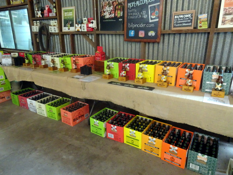
The Bilpin Cider Co. produces an extensive range of alcoholic and non-alcoholic cider products using only freshly crushed Australian apples.
Inside the storage shed at the Bilpin Cider Co. where you can choose the ciders you want to buy.
These apples were for sale in the Mountains Bell Cafe in Bilpin.


After lunch it was time to head back home and Nick, our driver, drove us back down to Richmond and back home via Castlereagh Road to Penrith.  We all enjoyed our day very much.  It was an extremely hot day, but very pleasant in the cooler environment of the Mountains.

Acknowledgments

1.  www.bluemountainsaustralia.com
2.  bilpinfruitbowl.com.au
3.  bilpincider.com


Friday, 13 January 2023

Barangaroo

Barangaroo

On Wednesday 11 January, 2023 we went by bus to Barangaroo Wharf in Sydney and did a walk northwards along the foreshore through Barangaroo Reserve.   

This area was once an industrial site, a disused container terminal which has now been transformed into a six hectare parkland.  There are beautiful views of Sydney Harbour and the Harbour Bridge.  There are lookouts, extensive walking and cycling trails, idyllic coves, picnic spots and places for quiet contemplation.  More than 75,000 native trees, palms, ferns and shrubs and other plants have been planted that are native to the Sydney region.  This once-scarred promontory is now visually reunited with Goat Island and its sister headlands at Balls Head, McMahons Point and Ballast Point.  Pyrmont and various other landmarks and destinations are also clearly visible.

The sandstone foreshore follows the natural Sydney fault line so the new headland is in line with natural Sydney Harbour headlands.  93% of the sandstone used was sourced from the on-site extraction pit.  Every grain of sandstone extracted was used.  Offcuts were ground up and mixed to become the sandy topsoil required by the newly planted trees and plants.  These trees and plants are thriving and already looking well established!

You can now walk along the foreshore between Walsh Bay and Cockle Bay which was once industrial and commercial land and off-limits to the public.  This walk is known as Wulugul Walk.   Wulugul is a local indigenous word for kingfish, a prize catch for Aboriginal people long before European settlement and still a delicious treat at many Sydney restaurants.  The wulugul/kingfish has a golden band along its blue-green skin, similar to the golden sandstone lining the blue of the harbour along the length of the new walk.   

The Gadigal people of the Eora nation are the traditional custodians of the land.  Barangaroo was a leader of the Cammeraygal people and wife of Bennelong of the Wangal people who played a significant role within her community and that of the early British colony.

On Monday of this week, Marrinawi Cove in the north-east corner of Barangaroo Reserve was opened for swimming.  A shark net has been installed across the ocean end of this sandstone-edged cove and also a shower on the shore. The NSW Government says this once neglected industrial western side of the Harbour has now been cleaned up and they will consider adding ladders and decking to Marrinawi Cove in the future, if the area proves popular for swimmers.  This area was used by the local Gadigal people for thousands of years as a fishing, canoeing and swimming spot, but has been off limits for Sydneysiders for the last few decades due to pollution and neglect.  It is wonderful that it has been restored to its former pristine condition.   

We weren't quite sure where Marrinawi Cove was situated and, unfortunately, we did not walk far enough to see the new swimming pool. 


Crown Sydney, also known as One Barangaroo is the tallest building in Sydney and makes a dramatic statement at the Wharf precinct in Barangaroo.  The stunning curve of the building derives inspiration from nature in the form of three "petals" that twist and turn rising upwards into the sky.
These steps rise up from Nawi Cove to the Stargazer lawn in Barangaroo Reserve at the top.
A view of the Anzac Bridge taken along the foreshore on the Wulugul Walk in Barangaroo Reserve.
At the Northern end of Wulugul Walk we were able to get a glimpse of the Sydney Harbour Bridge.
Back in the Wharf precinct stands Barangarooo House, a Matt Moran Restaurant on three levels.  Each level offers its own dining and drinking adventure.  There are plants spilling over the edges of each level.
I like the design of this building which features an innovative external diagrid structure wrapping the outside of the building.  It is the Macquarie Shelley Street Bank building behind Barangaroo House.

We had some lunch at the Bourke Street Bakery and then headed back to our meeting spot to catch up with our friends.  It wasn't long before Nick came in the bus to pick us up and drive us back home after a very enjoyable morning exploring Barangaroo.


Acknowledgments

1.  TimeOut.com
2.  Sydney Morning Herald
3.  Barangaroo.com
4.  fitzpatrickpartners.com 
5.  Wikipedia

Thursday, 15 December 2022

Katoomba

Echo Point

On Sunday 27 November, we went with the Travel Club for a trip in the double-decker Blue Mountains Explorer Bus to the tourist town of Katoomba in the Blue Mountains.  

Katoomba is 102 kilometres from Sydney and our journey started from the RSL Club in our home town of Penrith at the foot of the Blue Mountains.  From here it is a gradual ascent, via the Great Western Highway, passing through pretty Mountains townships, until we reached Katoomba, one of the highest towns in the Mountains.  It is 1017 metres above sea level and the air is fresh and much cooler than down on the Plains.   The name Katoomba is a Gundungurra Aboriginal word meaning "falling water".

We stopped at Echo Point and spent some time there, having a look around this fabulous place.   We had a good view of the iconic Three Sisters, located on the boundary of the Blue Mountains National Park.    Everyone who comes to visit Echo Point wants to take a photo or a selfie with the Three Sisters in the background.  We were no exception!  There are several viewing platforms at different levels where you can get good views.  We chose the Prince of Wales viewing platform with a great  view of the Three Sisters and the surrounding Valley. It was a clear day and the vast panoramic view over the Jamison Valley was stunning!  In the distance we could see Mt. Solitary.

The Blue Mountains is really a dissected plateau carved in sandstone bedrock.  This landscape was formed over 200 million years ago by land erosion during the Triassic Period.  It is hard to imagine this area was once covered by sea water!  

The Lookout area at Echo Point is well designed for the many tourists that visit, with paths and ramps for easy access.  Echo Point is also the starting point for many great walks, including the giant stairway that leads you down almost 1,000 steps to the valley floor below.  There is also a walk to the Ruined Castle which follows a route once used by shale and coal miners.  We called in at the Visitor Information Centre and had a look around its well-stocked shop with some good souvenirs and merchandise for sale.  

After a delicious lunch at Katoomba RSL Club we re-joined the bus for a drive along Cliff Drive passing Scenic World where the Skyway, Scenic Railway and Cableway are all available for a thrilling ride into the Valley.  The Scenic Railway is the steepest incline railway in the world and is a heartstopping drop down a cliff face to the valley below where there is an elevated boardwalk through the rain forest at the bottom of the valley.  However, there was no time to-day to experience these thrilling rides!

We continued down to the Katoomba Cascades where we stopped, as some people on the bus wanted to do the walk.  We waited in the Park at the top of the Cascades for these people to do the walk and then we all boarded the bus again for the scenic journey along Cliff Drive.  We stopped at Cahill's Lookout to view the breathtaking view over the Megalong Valley including Boar's Head Rock and Narrow Neck Peninsula.  The Narrow Neck Peninsula separates the Megalong Valley from the Jamison Valley.  

It was then time to re-join the bus for the return journey home, after an enjoyable day spent visiting some of our favourite places in our beloved Blue Mountains.

This is a view of the Three Sisters taken from the approach walk to the Prince of Wales Viewing Platform.  They are three tall unusual sandstone rock formations, that look like pillars, standing in the land of the Gundungurra and Darug people, the traditional custodians of this land.
A view of the escarpment at Echo Point.  This is one of my favourite views and I love to see the sandstone escarpment sparkle when the sun shines on it!
Looking through the trees along Prince Henry Cliff Walk to the escarpment that forms a boundary on one side of the Jamison Valley.


The view over the Megalong Valley from Narrow Neck Lookout
The Narrow Neck Plateau
is an eroded remnant of a sandstone layer at an elevation of 1000 metres above sea level which divides the Jamison and Megalong Valleys.  The Great Dividing Range is in the far distance.


Acknowledgments
1.  Wikipedia
2.  NSW National Parks and Wildlife Service.
3.  Sydney Uncovered 2022.
4.  aussietowns.com.au

Friday, 16 September 2022

Castlereagh

Castlereagh Conference Centre

On Monday 12 September we visited the Castlereagh Conference Centre in the historic Castlereagh area.  We drove to the end of Old Castlereagh Road and passed the Sydney International Regatta Centre, where the 2000 Sydney Olympics rowing events took place.  We came to a lake and a circular area for cars to turn around and go back, but we noticed a road continuing on with a signpost denoting the way to the Castlereagh Conference Centre.  There is a great deal of dredging and quarrying work being carried out on these rich alluvial river flats in connection with the Penrith Lakes Scheme which is making a huge impact on this historical area.  It is hard to see where the township is meant to be, but we did come to a flat section of the road with buildings on either side and we stopped here to investigate further.

On one side of the road is the Castlereagh Conference Centre incorporating some historical buildings including an old Methodist Church which is now the Castlereagh Uniting Church.  

This Church was built in 1847 and replaced an earlier Church which was the first Methodist Church in Australia.  It bears an inscription "Erected in the place of the First Wesleyan Chapel in Australia built by John Lees 1817".  The Uniting Church uses the Church and it is also used for weddings held in the Conference Centre.  It appears to be in good condition.  We could not go inside, but we peeped through the windows.  There is a graveyard at the side of the Church containing some old headstones dating back to Colonial times.

Castlereagh Church

Bell Tower

Vertical Sundial

School and War Memorial

Schoolmaster's Cottage


Behind the Church is a Bell Tower.   It looks like an old historical building, but it is actually fairly new and was opened on 24 June, 2001.  There are eight bells in the belfry and some of them were donated by the Kiama Anglican Church who were no longer using their bells.  There is a team of bell ringers who ring the bells on various occasions and it must be magical to hear the bells ringing out across the Penrith Lakes.  

On the outside North wall of the Bell Tower we noticed a vertical sundial called The Sacred Acre with a clock face and a quote attributed to John Wesley inscribed thereon:-   "Do all the good you can in all the places you can, at all the times you can, to all the people you can, as long as ever you can, by all the means you can, in all the ways you can."  

We picked up some brochures on the verandah outside the office for the Conference Centre advising the Centre was perfect for retreats, workshops or training days, only 4 minutes from Penrith but a world away in time and tranquility!  There is a meeting room with seating up to 80 people and air-conditioned twin bed accommodation up to 48 people with dining in the historic Sunday School House (1864).  There is also a Wedding Package including a ceremony in the Church with a minister or outside with a celebrant in the grounds and use of the garden and grounds with overnight guest accommodation.

On the other side of the road is the old Upper Castlereagh Public School, in poor condition and looking neglected with windows boarded over.  It was built by James Evans in 1878/9 and it is on the NSW State Heritage Register.  The roof is steeply pitched in corrugated iron and rusting.  It is a simple rectangular hall with attached side entry porch, typical of rural public schools of the period.  It is Gothic Revival in form and detailing with a Tudor arched entrance.  It was hard to see the porch as it was hidden behind the overgrown garden.

In the grounds of the school and closer to the road is a simple obelisk War Memorial honouring the men from Upper Castlereagh who served during WW1.  There are names on the Memorial, but the writing is very faint to read.  There is an inscription, barely legible, at the base of the Memorial - "Erected in honour of the above residents who enlisted from Castlereagth Upper for active service in the Great War 1914 - 1918."

Next-door to the School is the Schoolmaster's Residence which is a simple Victorian brick cottage with a hipped corrugated iron roof and front verandah.  It is surrounded by a garden, completely overgrown, but I did notice some nice original shrubs and plants amongst the weeds. The residence appears to be inhabited by a caretaker for the heritage precinct on both sides of the road.  In fact, we saw a man walking along the road and heading towards the cottage and he may well have been the caretaker.  We saw him walk through the front gate into the residence.  

We were excited to discover this wonderful historical area, so close to our home and decided to come back another day and take more photos.  On the way back we saw a little family of swans on the Lake, two black swans and three little white cygnets. Hopefully, we will discover more bird life on the Lakes, when we come back!

Acknowledgments

1.  Penrith City local history site. (information about Castlereagh Methodist Church)

2.  You Tube - Castlereagh Bell Tower  (information about Bell Tower)

3.  Wikipedia (information about Upper Castlereagh Public School)


Monday, 18 July 2022

South Australia

Victor Harbor and McLaren Vale 

After our wonderful day spent in the Barossa Valley, Di from Ambler Touring, arrived at our hotel the next morning, after brfeakfast, ready to take the six of us out for another day of touring.   Mary decided not to come and to have a day shopping in Adelaide.  Ernest sat up front next to the driver, Fred and Pam were in the middle and Ken and I were in the back.  Di said we had a big day ahead with our first stop at Victor Harbor.  I was pleased we were going there as Victor Harbor is one of my favourite spots in South Australia. I have happy memories of visiting Granite Island in the horse-driven tram across the Causeway to the island.  

We travelled South from Adelaide, using the Southern Expressway to enter the lush rolling wine country of the Fleurieu Peninsula.  We passed through McLaren Vale and Di said we would be calling in again at McLaren Vale, on the way back, to have lunch at a cafe there.

Causeway, Victor Harbor
As we entered the precinct around Victor Harbor, Di drove us to a lookout overlooking the panorama of Encounter Bay where we could get a glimpse of Granite Island.  

We then drove down to the township where there were roadworks taking place and I could see there were also road disruptions on the Causeway

There was no sign of the tram and I think the horses were having a holiday while the roadworks were in place.  

Di dropped us off at the Causeway Cafe where we had our morning coffee.  It was very cold and windy outside, so we were glad to sit inside where there was a slow combustion stove heating the interior.  

Paddle Steamer "Challenger"

We did not stay long in Victor Harbor and our next stop was Goolwa Wharf.  

Goolwa is a historic river port where the River Murray and the Southern Ocean meet.  It is a popular holiday destination.  There were boats at the wharf ready to take cruises on the Murray, even an old Paddle steamer.  

From the Wharf precinct we had a good view of the Hindmarsh Island Bridge, a controversial construction built in the 1990's which involved a clash with the local indigenous people over it being sacred cultural land where "secret women's business" supposedly took place. 

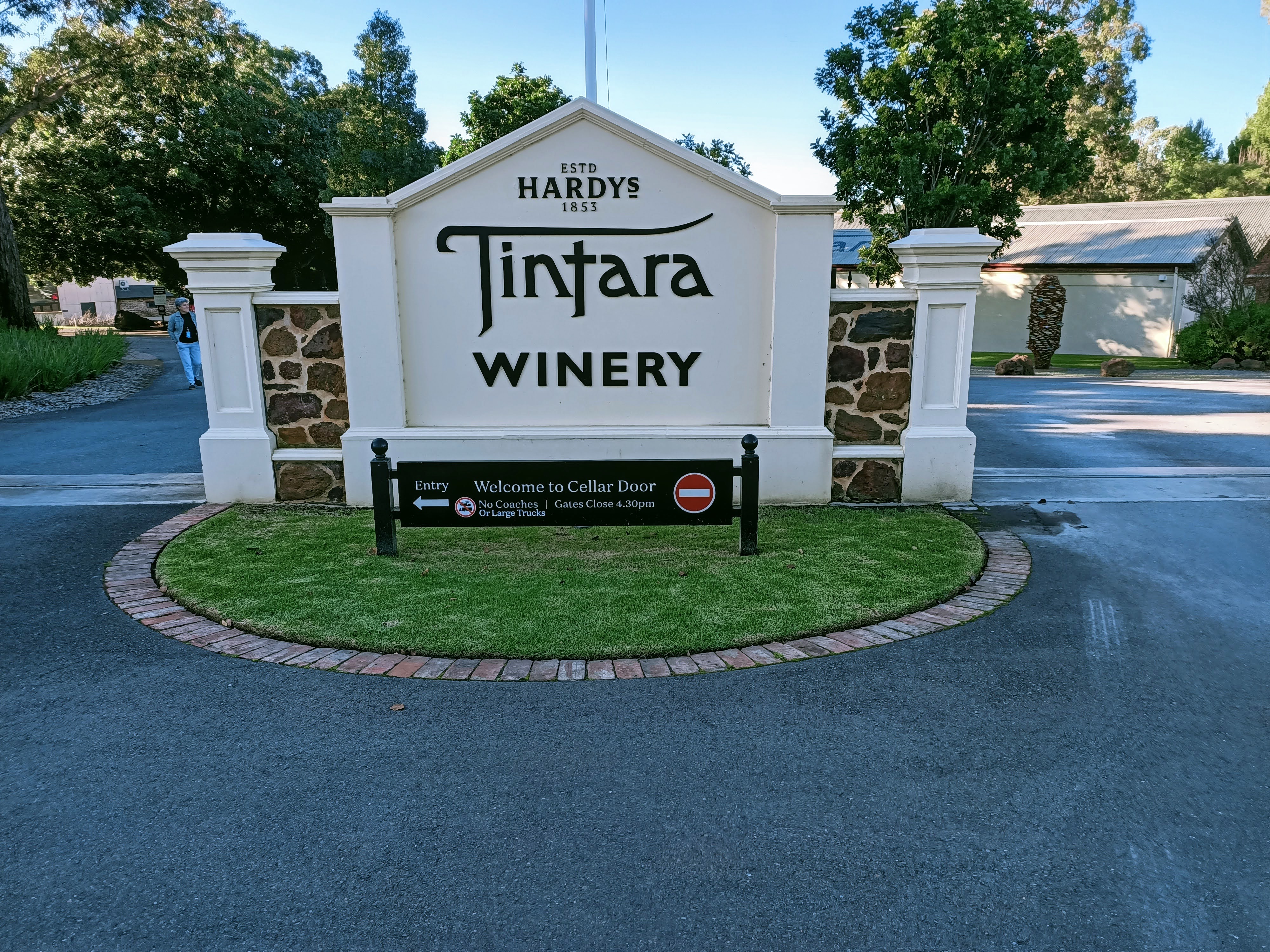
Tintara Winery

As it was time for lunch, Di was anxious to get back on the road for our lunch stop in McLaren Vale.  This charming town is in the heart of wine growing country and surrounded by more than one hundred vineyards and wineries.  

After lunch Di drove us to the Hardy Tintara Winery for a cellar door tasting and a walk around the grounds and the Almond Train next-door. This is an old 1920's train carriage which now seems to be a Japanese Kitchen cafe, but it was closed.


d'Arenberg Cube


Di then drove us to the d'Arenberg Winery and vineyard home to the unique d'Arenberg Cube.  This is a building, shaped like a Rubik's Cube, with five levels, carefully designed to entice and excite the senses with many tactile experiences.  We did not go inside as there was quite a lot of walking involved, but I am sure it would have been an amazing experience and the views from the top breathtaking.  There is also a Cellar door on the fifth floor. 

There was an exhibition of Salvadore Dali sculptures and also a sculpture retrospective in the grounds of the vineyard by artist Greg Johns titled "A Road less travelled"

Our time in the McLaren Vale was coming to an end and Di drove us back to our hotel in Adelaide after a very enjoyable day with many and varied experiences.  Di had done a good job of catering to our particular interests.  Fred and Pam were happy to visit the cellar doors and sample the wine tastings at the various wineries.  Mary was interested in buying gourmet food as in Maggie Beer's shop in the Barossa Valley the day before.  Ernest is keen on photographyand so are Ken and I, so the d'Arenberg Cube and sculptures in the d'Arenberg Vineyard was a great opportunity to take some interesting and unusual photos.

Salvadore Dali sculpture

Acknowledgements

1.  Alexandrina.sa.gov.au (information about Goolwa)

2.  darenberg.com.au (information about d'Arenberg Cube and Winery.